 For a map of the Rideau Canal Waterway System - Click Here
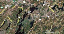
From the Rideau Canal, the 10km Tay Canal winds up the Tay River, through the Tay Marsh at the
Perth Wildlife Reserve, and into the
Tay River Basin in Perth. It is accessible from the Rideau Canal is by locking through the Beveridges Locks into the Tay Canal.
Check with Parks Canada before navigating up the Tay Canal for current draught, but the draught in the Tay Canal should be maintained the same as for the rest of the Rideau system.
Free boating and general information packages are available by contacting the Rideau Canal Office of Parks Canada at
613-283-5170 or by email at: RideauCanal-info@pc.gc.ca (please include your postal mailing address in your email) General Rideau info is available by calling the Parks Canada Call Centre at:
1-888-773-8888
Do You need a navigation chart?
Yes - two sets of navigation charts cover the Rideau. (Chart 1512 from Ottawa to Smiths Falls and Chart 1513 Smiths Falls to Kingston.) These charts show the depth of the water in all the lakes and rivers, and clearly show the navigation channel with all the marker buoys. These charts can be purchased at most lock-stations or can be ordered by phone
1-800-324-6052 or on-line from
Ontario Travel Guides.

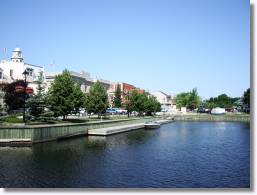
Downtown Perth can be reached from the Rideau Canal system via the Tay Canal, teminating at the Tay Basin. Large boats will find they cannot get any further than the Last Duel Park (where they can dock) because of very low bridges. Small boats should be able to navigate under these bridges and into the Tay Basin where there are docking facilities.
Beyond the Basin, the Tay River continues through the Tay Valley Township, offering some of the best paddling and wild-life viewing in the region.
Aerial View of Tay Canal Entrance Off The Rideau Canal

Click Here for Larger Map


